I recently had a discussion with someone on Facebook regarding the location of Upper Eastcott Farm Swindon. It started because of a photograph of a house in Eastcott Hill that has been named Eastcott Farm House.
I lived at the top of Eastcott Hill from birth to 9 years old when we moved in 1964 and I have some quite good memories of the area and I couldn’t remember a big smart house in this location. The photograph of the house and the Google Street View Image (I no longer live in Swindon) suggested to me that it was a recent building. The bricks looked too new to be around 160 years old and the whole style and demeanour if that is possible for a building, looked modern.
Oddly I picked up a book from my collection of Swindon titles; Swindon: An illustrated History and browsing I found an entry that referred to Upper Eastcott. I knew of Lower Eastcott Farm, it existed until XXX and is marked on maps to show its exact location but I had little knowledge of Upper Eastcott.
Upper Eastcott, so I have learnt is or rather was, the Hamlet that existed between Lower Eastcott Farm and Swindon as it was then, Swindon being a small village on the hill, a small part of the area now known as Old Town.
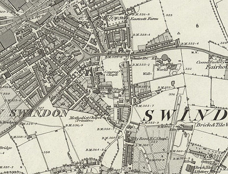
The earliest map I had seen until recently was one that is available on-line at www.oldmapsonline.org and is of the area concerned dated 1885 (published 1889) unfortunately it does not show Upper Eastcott which indicates that it had been built on.

Luckily I remembered that during a different discussion on Facebook someone had posted a section of a field map which shows the area before any building but does show railway land which would date it in the first half of the 1800’s. The map section includes the hamlet Upper Eastcott but rather frustratingly cuts off just south of the Hamlet of Upper Eastcott so does not show the area of the building we were discussing.
However what is fascinating is that the map of 1889 and the field map both show the ancient track way that went through Upper Eastcott, over the canal at Whale Bridge past Lower Eastcott Farm and over the area of land that was earmarked for the new Railway. It was clear to see how the old track way fitted into the newly emerging New Town. This allows for quite an accurate alignment of the two maps to identify locations on each map.
Now going back to the book I had randomly picked up pearlier, Swindon: An Illustrated History by Mark Childs. There is a short section about Eastcott and Upper Eastcott in particular. The passage reproduced here describes the track way and the hamlet.
The fields of Eastcott manor occupied much of the lower ground to the north of the town. From the town the hamlet of Eastcott was reached by a lane which followed the course of Eastcott Road and Eastcott Hill. Along this were scattered some twenty cottages; six thatched cottages in two groups of three stood on a bank on the side of the entrance to Crombey Street. Northwards the road ran between high stone walls to a small open space on the site of Regent Circus. On its east side were Upper Eastcott Farm and the manorial pound, and some ten or a dozen other houses were scattered near at hand; orchards occupied the area later covered by Regent Place. Here the ways branched; northwards a lane followed the course of the southern part of Princes Street then wound round Cow Lane, now a back way to the west. At the northern end of Cow Lane was a swing bridge over the canal, beyond which an unfenced track led along the edges of fields to Lower Eastcott Farm, on a site occupied in 1964 by the omnibus depot. North-westwards from Upper Eastcott another track ran through fields on the course of Regent Street, again crossing the canal by a swing bridge, to the point now the crossing of Bridge and Fleet streets. Here it met an ancient lane which ran south-westward toward Rushey Platt.
The person with whom I was discussing this claimed that the text; “On its east side were Upper Eastcott Farm and the manorial pound,” was evidence that the building was on the site of the old Upper Eastcott Farmhouse if not the actual building. I cannot agree as the evidence points to the farm being within the Hamlet and on the East (right hand) side of the Hamlet, rather than just the East Side of the Track Way.
Interestingly the text quoted has been copied and used on several different websites and was included in an Archaeological Report created in 2007 for an area at Regent Circus. Ref (REGENT CIRCUS, SWINDON Archaeological Desk Based Assessment Prepared By NETWORK ARCHAEOLOGY LTD On behalf of URS CORPORATION LTD For ASHFIELD LAND (SWINDON) LTD March 2007 Report Number 385). Unfortunately there are no maps associated with the website pdf but the text suggests that the area in question (PDA) was for the now completed development on the old College site.
The text quoted first describes the lane from Town (Old Town) to Upper Eastcott.
From the town the hamlet of Eastcott was reached by a lane which followed the course of Eastcott Road and Eastcott Hill. Along this were scattered some twenty cottages; six thatched cottages in two groups of three stood on a bank on the side of the entrance to Crombey Street.
Then it describes the hamlet.
On its east side were Upper Eastcott Farm and the manorial pound, and some ten or a dozen other houses were scattered near at hand; orchards occupied the area later covered by Regent Place.
Then it describes the section from Upper Eastcott to Lower Eastcott and beyond.
Here the ways branched; northwards a lane followed the course of the southern part of Princes Street then wound round Cow Lane, now a back way to the west. At the northern end of Cow Lane was a swing bridge over the canal, beyond which an unfenced track led along the edges of fields to Lower Eastcott Farm, on a site occupied in 1964 by the omnibus depot.
Finally the second branch from the hamlet.
North-westwards from Upper Eastcott another track ran through fields on the course of Regent Street, again crossing the canal by a swing bridge, to the point now the crossing of Bridge and Fleet streets. Here it met an ancient lane which ran south-westward toward Rushey Platt.
When reading this description in conjunction with the Field map it provides significant evidence to suggest that the location of Upper Eastcott Farm was the East Side of the hamlet.
 Also using this text, the field map and the 1885 map allows for a pretty accurate location to be determined of the land that was Upper Eastcott and is now Regent Circus. It is easy to follow the track from the bottom of Eastcott Hill from its junction with Crombey Street, angled across Regent Circus or specifically across the Town Hall and Library complex, to a point between the MECA (Old Odeon) and the office building next door where it turns North and under the existing section of Princess Street to a point where the Red Cow Stood until demolition in the 1970’s, and where the footbridge was until very recently, then the old track turned North Westward before turning again Northward to run parallel with the rear of the old line of Princess Street houses. There was a section of this track way in existence until the 1970’s called Cow Lane. It turned right again to re-join Princess Street before crossing the old canal at Whale Bridge.
We can place the area on the 1889 map quiet accurately as the old Holy Rood RC Church was on the existing corner of Regent Circus and the end of Victoria road, then known as New Road.
This means that we can easily identify the area occupied by the Hamlet of Upper Eastcott as the area now known as Regent Circus and the orchards being in the area of Theatre Square and its car park.
It is known that the original Red Cow stood on this track way and the Field Map shows a cluster of buildings just under half way between the hamlet and Whale Bridge which would indicate the pub’s location. (It was moved to the Princess Street location in XXXX when Princess Street became the thoroughfare of choice over Cow Lane)
I also remember that there was a row of two or three small very old cottages that stood at the bottom of Eastcott Hill on its East Side which are not there now. Checking the Land Registry website for 78 Eastcott Hill, the current address of the building named Eastcott Farm House, shows that there are no records of transactions prior to 1998. It could be that this was due to the conversion of the ‘Old Farm House’ into flats, but a building of such stature would likely have been photographed or mentioned somewhere in the many books written about Swindon, but as far as I am aware has not.
Almost all of the deduction is based on the text quoted in Mark Childs (and others) book so the accuracy of this interpretation is based on that. There may be further evidence to describe the location of Upper Eastcott Farm, it may show on the full copy of the field map I only have a section of or there may be another map that can clarify the location but given the evidence so far I am happy that the farm was in the hamlet of Upper Eastcott and is one of the black rectangles show


