Man with Pointy Stick
There are a selection of images that have a man using a white hand held arrow to point to something that have been named "Man with Pointy Stick". There is a board in the image which gives some information as to the location, but sadly does not provide an accurate map reference.
I am from Swindon and there is a good collection of these images from the Man with Pointy Stick Album available online at Flickr Man with Pointy Stick Album and have been shared often in Facebook pages. People often ask about the location and board information and there have been several wrong answers, so I have created this article to explain more about the information on the board.
There is no way of accurately placing the location of the image from the information on the board in the image, there is no reference available that does that. The best you can do is locate the image to a square 1 Kilometre by 1 Kilometre.
To illustrate how inaccurate the details are I have chosen four images from the Town Gardens area, an area I know very well.

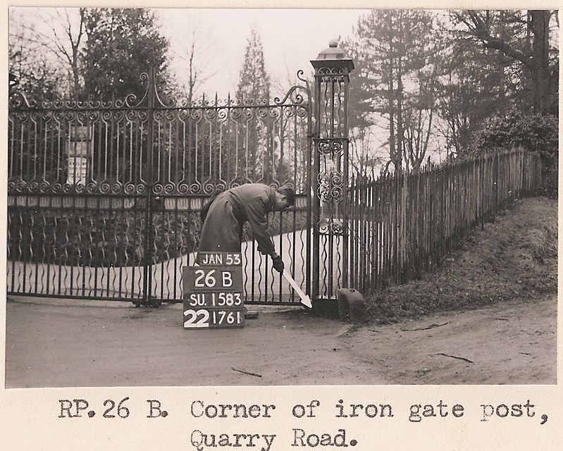
This image shows clearly that there are four quite different locations but the four boards are exactly the same information except for one line. That line is the Revision Point and shows as 26A, 26B, 23K and 23L.
These Revision Points were used specifically for the survey carried out at the time and are meaningless unless they can be referenced to a Master List which Ordinance Survey had at the time but appear not to have now. The closest you can get to a Grid Reference is with the third line which in this case is SU1583. This SU reference is a standard Four Figure Ordinance Survey Reference and is an area of 1 square Kilometre.
The best option is when there is information in the image that can be used to identify the location such as given in these images. The shelter I think is the one that was next to the cafe but is no longer there. The tree in 23K is on the path from the Rose Garden (in the distance on the left) towards the Bandstand which is behind you.
OS Map References are a combination of letters and numbers based on the size of the area that is being referred to.
A complete OS map reference has two letters and a 10 digit number and refers to a square of 1m by 1m.
Using the Revision Points 26A and 26B, the full ten digit OS Grid Reference would be
Gate Post RP 26A SU 15249 83632
Gate Post RP 26B SU 15238 83630
How the 10 Digit Ordinance Survey Grid Reference is broken down.
Using the Grid Reference of RP 26A (SU 15249 83632)
The two letters (SU) refer to a square on an OS map of 100km by 100km km square.
A four digit reference (SU 15 83) is a 1km by 1km square.
A six digit reference (SU 152 836) is 100m by 100m square.
An eight digit reference (SU 1524 8363) is a square of 10m by 10m.
So the full ten digit (SU 15249 83632) is a square of 1m by 1m.
Grid References are used at different levels of accuracy depending on the need. If you need to illustrate a 1m by 1m square you would use a ten digit grid reference. If you only needed to illustrate a 100m by 100m square you would use a six digit reference.
How you read a full ten digit map reference is available from various sources online.
There is a useful website where you can find OS Grid References Grid Reference Finder The accuracy of which depends on how close to the exact 1m by 1m square you are able to click with your mouse or even harder with a tap on a smart device.


